


The “birdbrain” advocates of the Durand Line in Afghanistan present their country as if it were a divinely ordained nation whose borders were drawn at the dawn of time — and any alteration to those borders is as sinful as tampering with the words of holy scriptures.
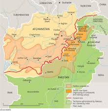
Afghanistan’s total area is around 650,000 square kilometers, and it shares borders with six countries: Pakistan, Iran, Turkmenistan, Uzbekistan, Tajikistan, and China. These borders were not created by nature. Instead, they were drawn through various agreements and treaties between different kingdoms and empires over time. The rulers of Afghanistan, in different eras, signed these agreements, and over time, political realities gave them permanence.
To the west, Afghanistan shares a 921-kilometer-long border with Iran. This border was peacefully demarcated in 1872 under the arbitration of Sir Frederic John Goldsmid, and the final agreement was signed under the MacMahon Commission in 1905. On both sides of this border, people speak the same language, follow the same religion, and share a common history and culture. Despite all this, both countries respect this border.
To the north, Afghanistan shares a border of 804 kilometers with Turkmenistan and 144 kilometers with Uzbekistan. The border with Tajikistan stretches for 1,357 kilometers. Interestingly, all these northern borders were drawn as a result of agreements between the British Empire and Russia in 1895 and 1896. Later in the 20th century, successive Afghan governments signed various treaties with the Soviet Union regarding these borders.
Afghanistan’s shortest border is with China — just 91 kilometers long — and it was peacefully settled through an agreement in 1963.
The most significant border, both politically and historically, is the one shared with Pakistan in the south and southeast. This border spans 2,670 kilometers and is known as the Durand Line. Contrary to the narrative of coercion, this border was not drawn by force; it was mutually agreed upon by all concerned parties.
The Durand Line was established in 1893 through an agreement signed between the then Emir of Afghanistan, Abdur Rahman Khan, and the British diplomat Mortimer Durand.
Later, after a change in the Afghan government, Amanullah Khan came to power and declared himself Emir. He initiated war against the British. As a result of this war, Afghanistan was defeated, and Afghan forces had to negotiate peace with the British. The final peace agreement was signed on August 8, 1919, in Rawalpindi, in what was then the province of Punjab. Article Five of this agreement recognized the Durand Line as the official border. A year later, the same agreement was reaffirmed.
When Pakistan was created in 1947, the then King of Afghanistan, Zahir Shah, refused to recognize the new state. During the vote for Pakistan’s membership in the United Nations, Afghanistan was the only country to vote against it. The Afghan ruler argued that since they did not recognize the Durand Line, they could not accept the existence of Pakistan either.
This has remained the stance of every Afghan government to this day.
The question is: If the borders drawn by the British with Russia and Iran are accepted by Afghanistan, then why is the border with Pakistan still not accepted?
By Muhammad Aslam


