


WASHINGTON: The United States Trade Representative (USTR) has taken down a controversial map of India from its official X (formerly Twitter) account following a strong diplomatic protest from Pakistan over the depiction of internationally recognised disputed territories as part of India, diplomatic sources told Dawn on Wednesday.
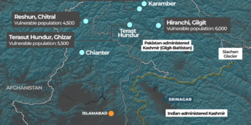
The map was shared alongside a USTR press release outlining a framework for an interim US-India trade agreement. It portrayed the entire Jammu and Kashmir region including Azad Jammu and Kashmir and Gilgit-Baltistan within India’s borders. It also showed China’s Aksai Chin region as Indian territory, despite the area being claimed by China and remaining disputed.
The post appeared on Friday evening but was removed by Monday evening, the first working day after the weekend.
Diplomatic sources said Pakistan raised the issue with both the US Embassy in Islamabad and State Department officials in Washington. Officials stressed that the depiction contradicted the longstanding US position that Jammu and Kashmir is a disputed territory whose final status must be resolved in line with relevant United Nations Security Council (UNSC) resolutions.
Sources familiar with the matter indicated that the map seemed to have been sourced from Google Maps, similar to a separate map used by the USTR in a press release regarding a trade agreement with Bangladesh.
Although the maps did not label specific regions and only showed territorial outlines, Pakistani officials argued that even an outline map issued by an official US body carries diplomatic and political significance particularly on a sensitive matter like Kashmir.
Concerns intensified after Indian media outlets highlighted the map as proof of an alleged change in US policy, interpreting it as implicit support for India’s claims over disputed areas.
Pakistani officials said this narrative made it necessary for Islamabad to promptly reiterate Washington’s consistent stance on Kashmir and to prevent any misinterpretation from gaining momentum.
While the USTR press release remains accessible on its website and social media accounts, the India map has been removed.
In contrast, the map accompanying the USTR’s press release on a trade arrangement with Bangladesh remains online, suggesting that the India map may have been posted inadvertently.
The issue surfaced as Washington and New Delhi announced over the weekend a framework for the initial phase of a bilateral trade deal aimed at expanding two-way trade.
Under the joint statement, the US will cut tariffs on Indian goods to 18 per cent after previously eliminating an additional 25pc punitive duty. Reciprocal tariffs are also expected to be reduced to comparable levels.
Pakistani officials maintained that the protest was unavoidable, especially in view of India’s unilateral move in August 2019 to revoke the special status of occupied Jammu and Kashmir a step Pakistan rejects as illegal, unconstitutional and contrary to international law.
Islamabad asserts that any official representation implying Indian sovereignty over the disputed territory undermines its UN-recognised status and weakens international commitments to neutrality.
The inclusion of Aksai Chin within Indian borders further heightened concerns, as it mischaracterised another unresolved territorial dispute and conflicted with Washington’s stated policy of not taking sides in India-China disputes.
US officials have yet to issue a public statement regarding the map’s removal. Pakistani diplomats noted that the episode underscores the importance of vigilance, as even technical or symbolic representations by influential global actors can carry serious diplomatic implications on an issue as sensitive and consequential as Kashmir.


